GeoMapping Intelligence answers the “where” question and enables businesses to make informed decisions
Do you know where your customers are located or where they interact with your brand or your competition? The importance of GeoMapping Intelligence to modern business is often overlooked by business decision-makers.
However, customer relationship management combined with geo-mapping intelligence can unlock many opportunities for companies looking to get the best out of mundane sales calls or are trying to gather intelligence for market expansion.
With this in mind leading market research company, Frontline Market Research , launched GeoMarketing Africa in 2008. The unit has since been incorporated into Frontline Strategic Projects, and specialises in integrating and mapping geographical information, with market research, providing geomapping intelligence for your business.
The mapping service has continued to evolve and now provides a variety of software solutions, aimed at assisting you to understand your market in greater detail.
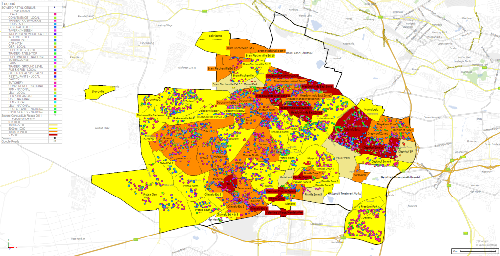
What is GeoMapping
Steve Johnson, a director at Frontline Market research says, “Simply put, GeoMapping is a technique used to visualise any business data with a location element (which most data has anyways). It turns data into something that is engaging and approachable – a map.”
GeoMapping Intelligence basically answers the “where” question, which a business can use to make informed decisions. This is mostly beneficial for companies doing business or looking to expand into Africa, where data on locations and potential customer demographics is often absent.
As a tool, this software enables businesses to visualise, analyse and share spreadsheet data, across multiple business functions such as sales, logistics, marketing and finance.
“Up to date, relevant African datasets, location geocoding and advanced routing solutions also form part of Frontline’s GeoMapping Intelligence product suite,” adds Steve.
Benefits of GeoMapping Intelligence
The power of GeoMapping Intelligence is its ability to give businesses the best local market knowledge. Since it’s visual, a company can quickly understand its market environment and seize on emerging opportunities.
That is because business transactions happen in a specific place, and that place usually influences customer preferences and behaviour.
Some advantages of GeoMapping Intelligence to business:
- Your company knows where its customers live, work and shop: GeoMapping’s power is in helping company decision-makers map and analyze customer location and demographic data. Consequently, companies are able to make data-driven decisions about site selection, marketing, and product assortment.
- Insights into why transactions happen where they do – Analysing map data can help with decisions such as inventory and marketing as a business can see where and how its customers interact with it.
- Best locations for stores / branches – As said above, for a company venturing into Africa for the first time, deciding on where to set up shop is not an easy task. Fortunately, GeoMapping can help predict the best or profitable locations based on an analysis of the presence of competition, customer demographics, access to supply chains, and more.
- Real-time data for real-time decisions – Because of its visual element, GeoMapping software helps companies make fast decisions on inventory, marketing and customers to take advantage on new opportunities in the marketplace.
- Easy to use – Frontline Strategic Projects provides expert mapping services and unique software, which adds spatial functionality and intelligence to the Microsoft Excel environment.
- Saves costs – Geomapping ensures that the quickest and least expensive distribution routes can be applied by the logistical arm of a company.
How Frontline Market Research’s GeoMapping Intelligence approach can help you win in trade
Steve says, “There is a saying that if you put garbage in you get garbage out…where Frontline excels is the accuracy of the data it collects, using our own software and then applying mapping analysis techniques that make the data come alive, offering clients a whole new perspective and birds eye view of market or of their data.”
Ultimately, your business has a better understanding of what is happening on the ground enabling you to make informed intelligent business decisions.
“We provide more than just software solutions, which are extremely user-friendly. We also assist with the strategy behind the data and how to use it to win, and to keep winning, right up to, and past, the last mile,” adds Steve.
Frontline Strategic Projects also offers consultancy services where they do the mapping for their clients. If you need data for a specific sector, such as census / population / demographic data or market-related data, they can provide these specific data sets for you, as well as integrate this data with your current available data.
Key GeoMapping solutions include:
- Geocoding services – generating coordinates of your retail database when they don’t have any.
- Strategic Rep and Delivery route planning – to optimise your cost to serve the market and overall efficiency of your fleet / people.
- Geotagging and data capturing software that is 100% customisable to your business needs.
Having a 100% accurate geolocation for every customer makes your data far more valuable and effective to planning your company’s Route to Market from the first mile to the last mile.
Frontline Market Research has a vast footprint in Africa. Any business that needs data to be provided or collected and viewed in a spatial context can make use of Frontline Strategic Projects GeoMarketing Intelligence team.
In addition to more than 20 years of market research experience and specialist Geographic Information Systems (GIS) staff, the company has access to a broad range of GIS databases and specialist technology.
Call Steve Johnson for a demonstration of how GIS can enhance your business: +27 86 999 0407
Follow more RNEWS articles, subscribe to our YouTube channel and for breaking news LIKE us on Facebook. For news on the Western Cape click here.